GeoEvident
Pinpoint photo locations and generate audit-ready reports.
11,251
Votes
10,628
Views
5,104
Bookmarks
About
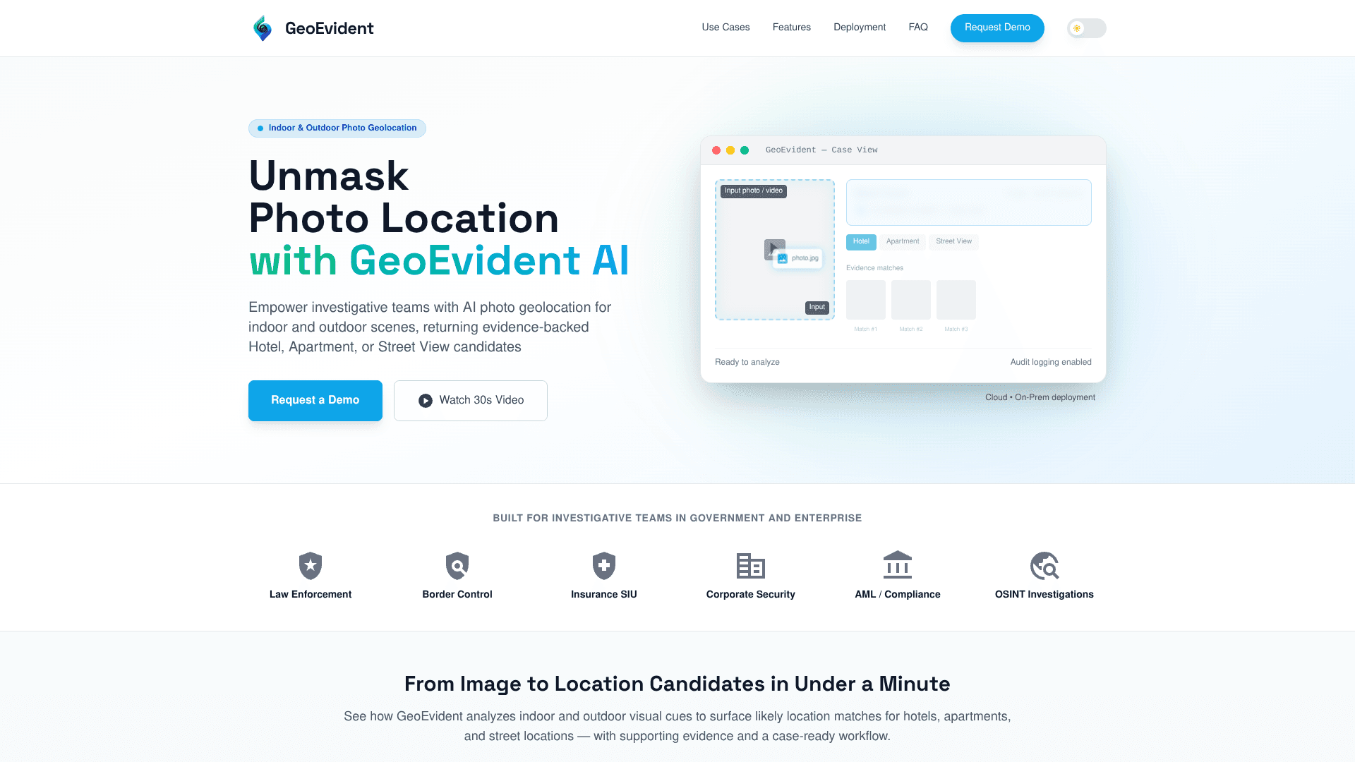
GeoEvident is an AI geolocation intelligence platform for investigative and risk teams that need to work out where photos and video frames were captured. It focuses on indoor and outdoor scenes, returning ranked hotel, apartment, and street-level candidates alongside visual evidence that analysts can review. The tool combines an AI vision engine with a case workflow that supports notes, audit trails, and exportable reports, and can be deployed either in managed cloud environments or fully on‑premise, including air‑gapped setups.
Key Features
- AI visual geolocation engine: Uses computer vision to analyze interiors, architecture, signage, and urban details, surfacing likely hotel, apartment, or street candidates within roughly a minute.
- Evidence-backed similarity views: Provides side‑by‑side comparisons with highlighted visual matches so analysts can see why a candidate location was suggested.
- Case-centric workflow and reporting: Organizes uploads, searches, analyst notes, and audit events into cases, with exportable case reports suitable for internal review or legal files.
- Enterprise controls and audit logging: Role-based access control, detailed audit logs, and configurable data handling policies support regulated and sensitive investigations.
- Flexible media support: Works with still images and extracted video frames, including content sourced from social networks where policies and legal basis permit.
Pros
- Investigation-ready design: Built for law enforcement, compliance, and corporate investigators rather than casual geolocation enthusiasts.
- Indoor and outdoor strength: Handles hotel rooms and apartments as well as street scenes and public venues.
- High transparency: Ranked candidates with visible evidence help analysts validate or challenge AI suggestions instead of accepting a black box answer.
- Deployment flexibility: Cloud and on‑premise or air‑gapped options fit strict data residency and security requirements.
- Case reporting: One-click style report generation reduces manual documentation work and supports consistent record keeping.
Cons
- No instant self-serve access: Teams must request a demo and go through a sales or vetting process.
- Enterprise focus only: Best suited to organizations with formal investigative workflows, not individual OSINT hobbyists.
- Dependent on visual cues and coverage: Generic interiors or very obscure locations will be harder to geolocate reliably.
Who Uses It
- Law enforcement and public safety agencies: Supporting investigations that rely on identifying hotels, apartments, or streets from seized imagery.
- Border control and migration authorities: Checking location claims and materials linked to border crossings or migration routes.
- Insurance SIU and fraud teams: Validating that claim photos align with declared locations and properties.
- Corporate security and financial crime units: Assisting AML and compliance staff when imagery is part of due diligence or risk reviews.
- Uncommon Use Cases: Suitable for academic labs studying photo geolocation workflows; attractive to NGOs documenting conflict or human rights imagery that later needs verifiable location analysis.
Pricing
- Enterprise licensing only: GeoEvident is accessed through organization-level agreements, typically following a demo and pilot rather than instant signup.
- Cloud deployment plans: Pricing is likely structured around annual subscriptions that include hosting, updates, and support for investigative teams.
- On-premise and air-gapped deployments: Usually sold as tailored licenses with implementation assistance for government and high-sensitivity environments.
You may also like
More tools in Business Tools

Smartsheet
Streamline workflows, automate tasks, enhance team collaboration.
Ipic.ai
AI-powered image enhancement for professionals and hobbyists alike.
Align AI
Streamlines AI strategy alignment with business objectives.
Outreach
Optimize sales, enhance workflows, boost efficiency with AI-powered tools.

super.AI
Automate complex document tasks with precision and efficiency.

Tom's Planner
Create efficient project plans in a breeze with Tom's Planner's AI-powered Gantt charts. Experience the future of project management by letting AI take the reins—no more manual entry! Just describe yo
Kira Systems
Streamline contract review with AI-driven precision and customization.

monday.com
Monday.com emerges as a vibrant and user-friendly project management platform, renowned for its intuitive drag-and-drop interface and an array of visual project planning tools. It is celebrated for fa
Tektonic AI
Streamline sales and revenue operations with advanced AI-driven automation.

adam.ai
Maximize your business success with adam.ai, the intuitive meeting management platform designed to enhance your team's productivity. Our intelligent solution streamlines the meeting process, granting
Looq AI
Revolutionize image analysis with advanced AI-powered recognition and insights.
AI Interior Designer By REimagineHome
Transform your real estate images with the cutting-edge AI Interior Designer tool, designed to breathe new life into every space. Experience the future of home visualization with our comprehensive sui